

The Yellow River is located in northern China, stretching west to east across northern China. It is one of China’s most important geographical features, shaping both the landscape and the development of early civilization.
The river begins in the Bayan Har Mountains on the Qinghai–Tibet Plateau, more than 4,200 meters above sea level. From this remote alpine region of wetlands and grasslands, it flows generally west to east, though its path bends dramatically northward and then southward before turning east again toward the sea.

After crossing plateaus, deserts, loess hills, and fertile plains, the Yellow River finally empties into the Bohai Sea in Shandong Province, forming the broad and sediment-rich Yellow River Delta.
On a map, the river’s winding course is often compared to the Chinese character “几”, reflecting its sweeping curves and directional shifts across northern China.
It flows through nine provinces, linking western highlands with eastern plains.
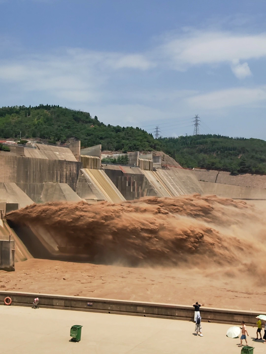
The Yellow River gets its distinctive color from the vast amounts of fine yellow silt it carries. Most of this sediment comes from the Loess Plateau, a region in north-central China covered with deep deposits of loose, wind-blown soil known as loess. This soil is extremely fine and easily eroded, especially during heavy summer rains.
As rainfall washes over the plateau, loose soil is swept into tributaries and eventually flows into the main river. Over time, this process has made the Yellow River the most sediment-laden major river in the world. The suspended particles give the water its muddy yellow-brown appearance and contribute to frequent riverbed changes and flooding in downstream areas.
Each year, the Yellow River carries an average of about 1.6 billion tons of sediment, a figure unmatched by most other rivers globally. Historically, large-scale deforestation and agricultural expansion increased soil erosion, exposing more loess to runoff and intensifying sediment transport.
The Loess Plateau contains some of the thickest wind-blown soil deposits on Earth.
Loose soil is easily washed into the river during monsoon rains.
Human land use and deforestation have accelerated erosion over centuries.
In short, the Yellow River is yellow because it flows through one of the world’s most erosion-prone landscapes, carrying its soil all the way to the sea.

Geography
The upper reaches of the Yellow River begin in the high-altitude Bayan Har Mountains on the Qinghai–Tibet Plateau. This section flows through vast grasslands, wetlands, and deep mountain valleys before entering parts of Gansu and Ningxia. The elevation remains high, and the climate is cool, with long winters and short summers.
Landscape
Here, the river is relatively clear compared to downstream sections. It winds through alpine meadows, glacier-fed lakes, and dramatic gorges. Snow-capped peaks, open skies, and wide pastoral scenery define the atmosphere. The environment feels remote and untouched, with fewer large cities along its course.
Best Scenic Spots
Sanjiangyuan (Three Rivers Source Area) – The ecological birthplace of the Yellow River, Yangtze, and Lancang rivers.
Eling Lake and Zhaling Lake – High-altitude freshwater lakes surrounded by wetlands and wildlife.
Lanzhou Zhongshan Bridge – A historic iron bridge offering classic river views in Gansu’s capital.
Why Visit
The upper reaches are ideal for travelers seeking open landscapes, Tibetan-influenced culture, and pristine plateau scenery. It’s the best section to experience the river in its most natural and least sediment-heavy form.

Geography
The middle reaches cross the Loess Plateau, a region known for thick wind-blown soil and dramatic terrain. The river cuts through narrow valleys and deep gorges, particularly along the border of Shanxi and Shaanxi provinces. This is where the river gathers large amounts of sediment.
Landscape
Steep cliffs, terraced hills, and rugged canyon scenery dominate this section. The river becomes visibly more yellow due to heavy silt. The terrain is bold and dramatic, shaped by erosion over thousands of years.
Best Scenic Spots
Hukou Waterfall – The river narrows sharply before plunging into a roaring, golden cascade.
Jin–Shaan Grand Canyon – A spectacular stretch of cliffs and winding river bends.
Longmen (Dragon Gate) Gorge – Known for its steep rock walls and legendary cultural significance.
Why Visit
If you want to see the Yellow River at its the most dramatic and visually striking section, the middle reaches offer the most dramatic views. This section combines raw natural energy with strong cultural symbolism.

Geography
The lower reaches extend across the North China Plain toward the Bohai Sea. The terrain becomes flat and more densely settled, with farmland and cities surrounding the riverbanks. Over centuries, sediment deposition has raised the riverbed above the surrounding land in some areas.
Landscape
Here, the river flows more slowly and widely. The environment transitions into fertile plains and wetlands. The Yellow River Delta near the sea is a vast ecological zone formed by accumulated silt, creating new land over time.
Best Scenic Spots
Yellow River Delta National Nature Reserve – A major wetland habitat for migratory birds.
Jinan Yellow River Scenic Area – Riverside parks and viewpoints near the “City of Springs.”
Kaifeng Riverside Historic Area – Cultural sites reflecting the region’s long history.
Why Visit
The lower reaches are ideal for travelers interested in wetlands, birdwatching, and agricultural landscapes. It is also the easiest section to access from major cities, offering a balance of nature and cultural heritage.
Below are some of the most iconic and scenic destinations along the Yellow River, covering its upper, middle, and lower reaches. Each offers a different perspective on China’s “Mother River.”

Location: Border of Shanxi and Shaanxi Provinces
Why it’s famous:
Hukou Waterfall is the most dramatic and powerful sight on the Yellow River. Here, the wide river suddenly narrows and plunges into a deep gorge, creating a roaring curtain of muddy yellow water. It is often described as the river at its most intense and symbolic.
Best time to visit:
Late spring (April–May) and autumn (September–October) when water levels are strong but weather is comfortable.
Travel tip:
Visit from both the Shanxi and Shaanxi sides for different viewing angles of the waterfall.

Location: Tangke Town, border of Sichuan and Gansu
Why it’s famous:
This sweeping curve of the river across vast grasslands is one of the most photogenic river landscapes in China. The wide golden river against green prairie creates a peaceful, cinematic view.
Best time to visit:
Summer (June–August) for lush grasslands and clear skies.
Travel tip:
Climb to the viewing platform near sunset for the best panoramic photos.

Location: Southern Qinghai Province
Why it’s famous:
Sanjiangyuan is the ecological source region of the Yellow River, Yangtze River, and Lancang River. It features wetlands, snow-capped mountains, and pristine alpine scenery.
Best time to visit:
Late spring to early autumn (May–September).
Travel tip:
Prepare for high altitude; acclimatize slowly and avoid strenuous activity on arrival.

Location: Dongying, Shandong Province
Why it’s famous:
Formed by centuries of sediment deposition, the delta is a vast wetland ecosystem and one of China’s most important bird migration habitats.
Best time to visit:
Autumn (September–November) for migratory birds and golden reed fields.
Travel tip:
Bring binoculars if you enjoy birdwatching.

Location: Lanzhou, Gansu Province
Why it’s famous:
Built in 1907, Zhongshan Bridge is the first permanent bridge over the Yellow River. It combines industrial history with scenic riverside views.
Best time to visit:
Evening, when the bridge is illuminated.
Travel tip:
Combine your visit with a riverside walk and try Lanzhou hand-pulled noodles nearby.

Location: Zhongwei, Ningxia
Why it’s famous:
Shapotou offers the rare sight of the Yellow River flowing beside desert dunes. Visitors can experience camel rides, sand sliding, and traditional sheepskin rafting.
Best time to visit:
May to October for outdoor activities.
Travel tip:
Visit early morning or late afternoon to avoid extreme desert heat.

Location: Near Hejin, Shanxi Province
Why it’s famous:
This narrow gorge along the middle reaches features steep cliffs and historical associations with ancient flood-control legends.
Best time to visit:
Spring and autumn for mild weather.
Travel tip:
Pair your visit with nearby cultural sites in the Shanxi region.

Location: Henan Province
Why it’s famous:
This park offers accessible viewpoints of the lower reaches, cultural monuments, and large statues symbolizing the river’s importance.
Best time to visit:
Spring and autumn.
Travel tip:
It’s easily combined with a trip to Shaolin Temple in Dengfeng.

Location: Border of Shanxi and Shaanxi
Why it’s famous:
This canyon section showcases rugged cliffs and winding river bends carved into the Loess Plateau.
Best time to visit:
Late summer to autumn when water levels are moderate.
Travel tip:
Check road conditions in advance, as access can be limited in remote areas.
Together, these destinations reveal the Yellow River’s full character—from alpine wetlands and grasslands to roaring waterfalls, deserts, fertile plains, and coastal wetlands—making it one of China’s most geographically diverse travel experiences.
The Yellow River Basin is widely regarded as the cradle of Chinese civilization. Early communities settled along its fertile plains, developing farming, pottery, and social organization thousands of years ago.

One of the most important cultures was the Yangshao culture (c. 5000–3000 BC). Archaeological sites such as Banpo near Xi’an reveal:
Organized village layouts
Painted pottery and craft specialization
Evidence of millet farming and animal domestication
These findings show that complex community life existed along the Yellow River more than 6,000 years ago.
As agriculture strengthened the region, major capitals emerged within the basin. During the Qin and Han dynasties, cities near modern Xi’an and Luoyang became political and administrative centers. From here, writing systems, laws, and governance models spread across northern China.
Beyond archaeology and imperial history, the Yellow River holds lasting symbolic meaning. It represents resilience and continuity. Despite floods and environmental challenges, it sustained generations of communities and shaped the identity of the Chinese nation.
Today, the river remains both a geographical landmark and a powerful cultural symbol of origin and endurance.

While the Yellow River is known as the “Mother River,” it is also called “China’s Sorrow.” This name reflects its long history of destructive floods and dramatic course changes.
The river carries enormous amounts of loess sediment from the Loess Plateau. As silt accumulates in the lower reaches, the riverbed gradually rises. Over centuries, this created the famous “suspended river” phenomenon, where parts of the river flow several meters above surrounding farmland and cities, held back only by levees.
Historically, the Yellow River was one of the most unstable rivers in the world.
Major challenges included:
More than 1,500 recorded floods, many causing famine and displacement
Over 20 major course changes, reshaping northern China
Heavy sediment buildup, increasing pressure on embankments
Before modern engineering, flood disasters here were among the deadliest natural events in Chinese history.
Today, dams, reservoirs, and sediment-control systems have greatly reduced the risk. Yet the river’s powerful sediment load still demands constant management.
The name “China’s Sorrow” reminds us that this river has shaped China not only through nourishment, but also through hardship.

The Yellow River remains one of China’s most important waterways, but it also faces serious environmental pressures. Modern engineering has reduced flood disasters, yet long-term sustainability remains a complex challenge.
Key issues include:
Drought and Water Scarcity – The basin has limited per-capita water resources, and parts of the lower reaches have experienced seasonal drying in past decades. Agricultural irrigation, industry, and urban demand place additional stress on already constrained supplies.
Pollution – Rapid industrialization and urban growth have introduced wastewater and agricultural runoff into sections of the river. Although water quality has improved in many areas, pollution remains uneven across regions.
Sediment Management – The Yellow River carries one of the highest sediment loads of any major river. Managing silt through reservoirs and controlled releases is necessary to prevent riverbed elevation and downstream flooding risks.
Climate Change Impacts – Rising temperatures, shifting precipitation patterns, and glacier retreat in the upper plateau may influence long-term flow stability. Increased variability could intensify both drought and flood extremes.
These environmental challenges reflect the river’s delicate balance between natural forces and human activity. The Yellow River is no longer defined only by floods, but by how effectively water resources, sediment, and ecosystems are managed in a changing climate.
The Yellow River stretches across diverse climates and landscapes, so the best time to visit depends on what you want to experience. Spring and autumn generally offer the most comfortable weather, while summer provides dramatic water views.
Season | Best For | Notes |
|---|---|---|
Spring (Apr–May) | Mild weather, grasslands, Qinghai Lake | Comfortable temperatures and blooming landscapes in upper reaches; occasional wind in plateau areas. |
Summer (Jun–Aug) | Powerful waterfalls, lush scenery | Peak water flow makes Hukou Waterfall especially impressive; hotter in lower reaches and possible rainstorms. |
Autumn (Sep–Oct) | Clear skies, desert views, photography | Stable weather, golden loess landscapes, and fewer crowds in many areas. Ideal for Longmen Gorge and Shapotou. |
Winter (Nov–Mar) | Frozen river scenes, snow landscapes | Dramatic icy views in the north; very cold in upper and middle reaches; some remote areas may be less accessible. |
The Yellow River flows through plateaus, gorges, plains, and deserts. Conditions vary greatly by region, so planning ahead will help ensure a smooth and safe trip.
Swimming is generally not recommended. The river carries heavy sediment and strong currents, especially in the middle and lower reaches. Water depth and flow can change quickly, making many sections unsafe for recreational swimming.
Hukou Waterfall is most powerful in the rainy season. From July to September, water volume increases significantly, creating dramatic views — but also stronger spray and slippery surfaces. Wear non-slip shoes and protect cameras from mist.
Watch for altitude effects in the upper reaches. Areas near the source in Qinghai sit above 3,000–4,000 meters. Some travelers may experience mild altitude symptoms such as headaches or fatigue. Move slowly and stay hydrated.
Prepare for strong sun in desert regions. Places like Shapotou and parts of Ningxia have intense sunlight and dry air. Sunscreen, hats, sunglasses, and adequate water are essential.
Plan transportation carefully. The river spans nine provinces, and scenic spots are widely dispersed. High-speed trains connect major cities like Lanzhou, Zhengzhou, and Jinan, but reaching remote sections often requires private transport or guided tours.
Because the Yellow River covers such a vast area, it is best to focus on one or two regions rather than trying to see everything in a single trip.
China’s two most famous rivers are the Yellow River (Huang He) and the Yangtze River (Chang Jiang). While both are historically important, they differ greatly in geography, size, and cultural influence.
Feature | Yellow River (Huang He) | Yangtze River (Chang Jiang) |
|---|---|---|
Length | 5,464 km (3,395 mi) | 6,300 km (3,915 mi) |
Rank in China | 2nd longest | Longest |
Region | Northern China | Central & Southern China |
Nickname | Mother River / China’s Sorrow | Golden Waterway |
Sediment Level | Extremely high (world’s muddiest major river) | Relatively low |
Flood History | Frequent historic floods | Also floods, but less sediment-driven |
Economic Role | Agriculture-focused basin | Major shipping & industrial corridor |
The Yellow River is more closely tied to early Chinese civilization and ancient northern capitals. The Yangtze, on the other hand, plays a larger role in modern transportation and economic development.


Heilongjiang, known for its winter wonderland, is a top ice-snow tourism destination with iconic sites like Harbin Ice Festival and China Snow Town. It also boasts stunning natural beauty.

Explore Beijing’s top attractions, historical sites, and hidden gems. Your ultimate travel guide to China’s vibrant capital city.

Learn the best ways to get to Wuhan by train, flight, bus, car, or transfer, with arrival tips for domestic and overseas travelers.

Plan your 2-day Chongqing trip: high-efficiency itinerary covering landmarks, night views, magical topography, food, budget, and must-avoid mistakes.

Explore Jinan, the City of Springs, known for its cultural heritage, stunning Daming Lake, Baotu Spring, and breathtaking modern skyline.

Find the best area to stay in Lhasa for first-time trips, old-town walks, quiet rest, high-altitude comfort, and practical rail transit stays.


